
Denver/Longmont and Front Range Colorado Version
WARNING: THIS PAGE IS somewhat SLOW TO LOAD.
Curated by John E. at www.bikerjohn.com
NWS Surface Map

The Weather Channel's Surface Map

Click above, map will not load now..
The Weather Underground Surface Map

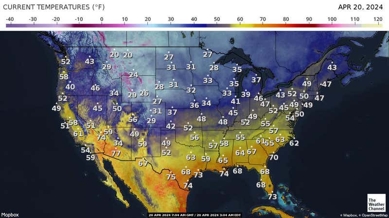
The Weather Underground Surface Temperatures
![]()
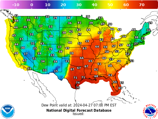
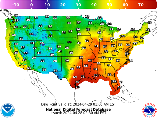
The Weather Underground Surface Dew Points
The Weather Underground Surface Heat Index
![]()
![]()
The Weather Underground Wind Chill
![]()
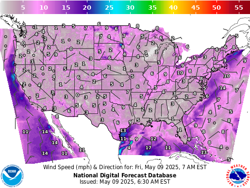
The Weather Underground Surface Winds
UNISYS Surface Obs
or go to Weather Prediction Center Surface Obs

The Oklahoma
Mesonet
Surface Temperatures, Dew Points
Winds, Rainfall
![]()
NCAR/RAP Visible Satellite
http://www.aviationweather.gov/adds/satellite/displaysat?region=DEN&isingle=mult_big&itype=vis
http://www.aviationweather.gov/adds/satellite/displaysat?region=US&isingle=mult_big&itype=vis

NCAR/RAP Infrared Satellite
http://www.aviationweather.gov/adds/satellite/displaysat?region=DEN&isingle=mult_big&itype=irbw
http://www.aviationweather.gov/adds/satellite/displaysat?region=US&isingle=mult_big&itype=irbw

NCAR/RAP Water Vapor Satellite
http://www.aviationweather.gov/adds/satellite/displaysat?region=DEN&isingle=mult_big&itype=wv
http://www.aviationweather.gov/adds/satellite/displaysat?region=US&isingle=mult_big&itype=wv

NWS Radar Image - The Denver Area
NWS Regional Radar Image The Denver Area
NWS Radar Storm Total Precip. Image for Denver
National RADAR from Weatherunderground

Mountain RADAR from Weatherunderground

![]()
The Severe Storms Prediction
Center
Current Mesoscale Discussions, The Day 1 (today) Severe Weather Outlook

http://www.spc.noaa.gov/products/md/
http://www.spc.noaa.gov/products/outlook/day1otlk.html
The Severe Storms Prediction
Center
The Day 1 (today) Tornado Probability map

The Severe Storms Prediction
Center
The Day 1 (today) Severe Winds Probability map

The Severe Storms Prediction
Center
The Day 1 (today) Large Hail Probability map

The Severe Storms Prediction
Center
The Day 2 (tomorrow) and Day 3 (the next day) Severe Weather Map


NCAR/RAP KDNR Sounding - Denver International Airport

FORECAST MAPS


FROM UCAR


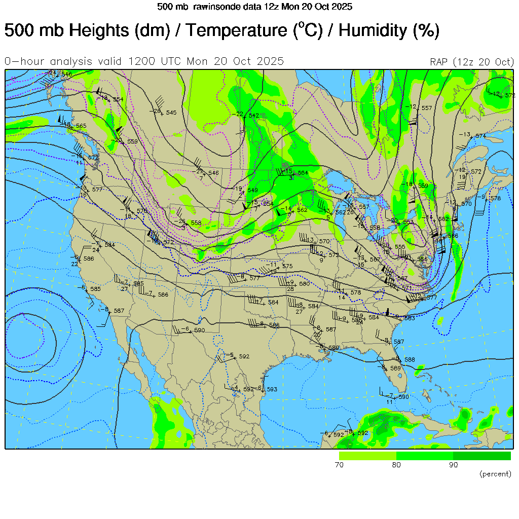
NCAR/RAP 500mb Map
NCAR/RAP GFS Forecast 500mb
Map
Today + 1 day
NCAR/RAP GFS Forecast
Surface Map
Today + 1 day
NCAR/RAP GFS Forecast
500mb Map
Today + 2 days
NCAR/RAP GFS Forecast Surface
Map
Today + 2 days
NCAR/RAP GFS Forecast
500mb Map
Today + 3 days
NCAR/RAP GFS Forecast
Surface Map
Today + 3 days
NCAR/RAP GFS Forecast
500mb Map
Today + 4 days
NCAR/RAP GFS Forecast
Surface Map
Today + 4 days
NCAR/RAP GFS Forecast
500mb Map
Today + 5 days
NCAR/RAP GFS Forecast
Surface Map
Today + 5 days
NCAR/RAP GFS Forecast
500mb Map
Today + 6 days
NCAR/RAP GFS Forecast
Surface Map
Today + 6 days
NCAR/RAP GFS Forecast
500mb Map
Today + 7 days
NCAR/RAP 200mb Map
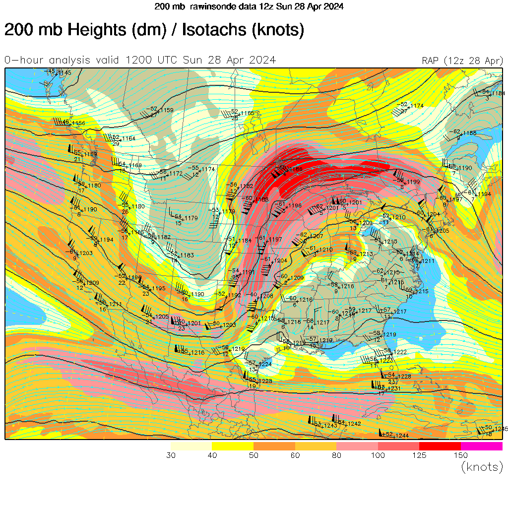
Jet Stream map
30 Day Temperature Forecast

30 Day Precipitation Forecast

90 Day Temperature Forecast

90 Day Precipitation Forecast

Unisys Forecast Maps - The RAP Model
Unisys Forecast Maps - The ECMWF Model
Unisys Forecast Maps - The NAM/Wrf Model
Unisys Forecast Maps - The GFS/Avn Model
The Weather Underground Tropical Activity Map TROPICS SECTION
El Nino Status
